![](/images/other/stat-length.png)
![Randonnée Vélo Le Verdon-sur-Mer - Le Verdon - Blaye - Le Verdon - Photo](https://media.geolcdn.com/t/1900/400/ext.pjpeg?maxdim=2&url=https%3A%2F%2Fstatic1.geolcdn.com%2Fsiteimages%2Fupload%2Ffiles%2F1524743154velo.jpg)
Le Verdon - Blaye - Le Verdon
tracegps
Utilisateur
![Longueur](/images/other/stat-length.png)
![Altitude max](https://static1.geolcdn.com/siteimages/upload/files/1508320355ic_sort_altitude_max_24dp.png)
![Dénivelé positif](https://static1.geolcdn.com/siteimages/upload/files/1508320355ic_sort_den_pos_24dp.png)
![Km-Effort](/images/other/stat-length.png)
![Altitude min](https://static1.geolcdn.com/siteimages/upload/files/1508320355ic_sort_altitude_min_24dp.png)
![Dénivelé négatif](https://static1.geolcdn.com/siteimages/upload/files/1508320355ic_sort_den_neg_24dp.png)
![Boucle](https://static1.geolcdn.com/siteimages/upload/files/16400158638029165_repeat_loop_refresh_sync_direction_icon.png)
![Vélo](https://static1.geolcdn.com/sitytour/trail-icons/200.png)
8h45
Difficulté : Moyen
![Scannez ce code QR pour ouvrir la randonnée dans l'application SityTrail](https://capi.geolives.com/qq0zvz2zws4bq2lad0pu/sitytour/trails/105454/qr.png?size=200)
Application GPS de randonnée GRATUITE
À propos
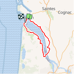
Randonnée Vélo de 177 km à découvrir à Nouvelle-Aquitaine, Gironde, Le Verdon-sur-Mer. Cette randonnée est proposée par tracegps.
Description
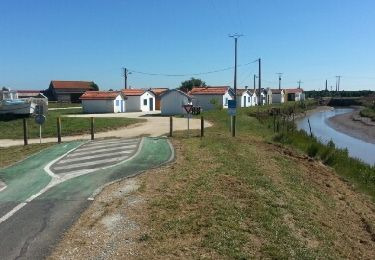
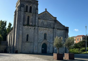
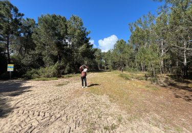
Départ du Verdon sur Mer en direction de Lamarque, on longe la Gironde par la route des Vins. Les petites routes passent à travers le vignoble bordelais au pied de beaux châteaux. A Lamarque, embarquer sur le bac pour traverser la Gironde, il faut environ 20mn pour arriver à Blaye. Au retour on passe dans le vignoble des célèbres 'Côte de Blaye'. le parcours retour est plus vallonné. A Royan il faut reprendre le bac pour traverser l'estuaire jusqu'au Verdon sur Mer.
Localisation
Commentaires
Randonnées à proximité
![Randonnée Marche Le Verdon-sur-Mer - Verdon, Soulac (Boucle) - Photo](https://media.geolcdn.com/t/375/260/c625806c-3ea6-4a4c-99da-c5e355e3ec6c.jpg&format=jpg&maxdim=2)
![Marche Marche](https://static1.geolcdn.com/sitytour/trail-icons/101.png)
Marche
![](/images/other/stat-length.png)
![](https://static1.geolcdn.com/siteimages/upload/files/16400158638029165_repeat_loop_refresh_sync_direction_icon.png)
![Randonnée Marche Le Verdon-sur-Mer - Verdon, Rocher Saint Nicolas, Pointe de Grave (Boucle) - Photo](https://media.geolcdn.com/t/375/260/dce728d2-b7ab-4a70-a416-b2d6b8f699d5.jpg&format=jpg&maxdim=2)
![Marche Marche](https://static1.geolcdn.com/sitytour/trail-icons/101.png)
Marche
![](/images/other/stat-length.png)
![](https://static1.geolcdn.com/siteimages/upload/files/16400158638029165_repeat_loop_refresh_sync_direction_icon.png)
![Randonnée Vélo Le Verdon-sur-Mer - Vélodyssée de la pointe de Grave à Arès - Photo](https://media.geolcdn.com/t/375/260/ext.jpg?maxdim=2&url=https%3A%2F%2Fservices.sitytrail.com%2FGeolivesWS%2FDownloadMedia.ashx%3FTrailID%3D450844%26Media%3Dda502f19-850a-427f-b3b1-0ab003fea88d.jpg)
![Vélo Vélo](https://static1.geolcdn.com/sitytour/trail-icons/200.png)
Vélo
![](/images/other/stat-length.png)
![](https://static1.geolcdn.com/siteimages/upload/files/16400158638029165_repeat_loop_refresh_sync_direction_icon.png)
![Randonnée V.T.T. Le Verdon-sur-Mer - De l océan à l estuaire de la Gironde - Photo](https://media.geolcdn.com/t/375/260/ext.jpg?maxdim=2&url=https%3A%2F%2Fservices.sitytrail.com%2FGeolivesWS%2FDownloadMedia.ashx%3FTrailID%3D209256%26Media%3Dfix__20130731173143.jpg)
![V.T.T. V.T.T.](https://static1.geolcdn.com/sitytour/trail-icons/202.png)
V.T.T.
![](/images/other/stat-length.png)
![](https://static1.geolcdn.com/siteimages/upload/files/16400158638029165_repeat_loop_refresh_sync_direction_icon.png)
![Randonnée Marche nordique Soulac-sur-Mer - Gr81 de Soulac à St Vivien - Photo](https://media.geolcdn.com/t/375/260/2c96e290-a48a-4d7a-9bff-aed1e2b25618.jpg&format=jpg&maxdim=2)
![Marche nordique Marche nordique](https://static1.geolcdn.com/sitytour/trail-icons/102.png)
Marche nordique
![](/images/other/stat-length.png)
![](https://static1.geolcdn.com/siteimages/upload/files/16400158638029165_repeat_loop_refresh_sync_direction_icon.png)
![Randonnée sport Le Verdon-sur-Mer - Maison de Grave - Photo](https://media.geolcdn.com/t/375/260/ccf6abee-987a-4ce0-a415-3c8243d89484.jpg&format=jpg&maxdim=2)
sport
![](/images/other/stat-length.png)
![](https://static1.geolcdn.com/siteimages/upload/files/16400158638029165_repeat_loop_refresh_sync_direction_icon.png)
![Randonnée Randonnée équestre Le Verdon-sur-Mer - Vers la Pointe de Grave - Photo](https://media.geolcdn.com/t/375/260/ext.jpg?maxdim=2&url=https%3A%2F%2Fstatic1.geolcdn.com%2Fsiteimages%2Fupload%2Ffiles%2F1524743154cheval.jpg)
![Randonnée équestre Randonnée équestre](https://static1.geolcdn.com/sitytour/trail-icons/301.png)
Randonnée équestre
![](/images/other/stat-length.png)
![](https://static1.geolcdn.com/siteimages/upload/files/16400158638029165_repeat_loop_refresh_sync_direction_icon.png)
![Randonnée V.T.T. Le Verdon-sur-Mer - chenal de Capsey - Photo](https://media.geolcdn.com/t/375/260/ext.jpg?maxdim=2&url=https%3A%2F%2Fstatic1.geolcdn.com%2Fsiteimages%2Fupload%2Ffiles%2F1524743154velo.jpg)
![V.T.T. V.T.T.](https://static1.geolcdn.com/sitytour/trail-icons/202.png)
V.T.T.
![](/images/other/stat-length.png)
![](https://static1.geolcdn.com/siteimages/upload/files/16400158638029165_repeat_loop_refresh_sync_direction_icon.png)
![Randonnée Course à pied Le Verdon-sur-Mer - sentier vtt + gr8 - Photo](https://media.geolcdn.com/t/375/260/ext.jpg?maxdim=2&url=https%3A%2F%2Fstatic1.geolcdn.com%2Fsiteimages%2Fupload%2Ffiles%2F1524743154running.jpg)
![Course à pied Course à pied](https://static1.geolcdn.com/sitytour/trail-icons/103.png)
Course à pied
![](/images/other/stat-length.png)
![](https://static1.geolcdn.com/siteimages/upload/files/16400158638029165_repeat_loop_refresh_sync_direction_icon.png)